GUIDE · RANDOM MAPS
Dorothea Quarry
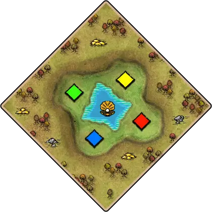
A deep central basin contains water and oysters, while surrounding heights lead toward exposed forests and resources.
Overview
A deep central basin contains water and oysters, while surrounding heights lead toward exposed forests and resources.
Map type and generation
Dorothea Quarry is listed as Water, with the features Water & crossings, Forests & woodlines, Contested center, High ground. Its recorded map scope is Standard. These labels describe the kind of terrain and match setup to expect; they do not guarantee that every generated map places resources in the same location.
Planning a match
Check shore access and fish before committing to docks; on mixed land-and-water layouts, keep enough land defense to protect the economy while the fleet contests fishing or crossings. Identify the few usable entrances and secure them deliberately. Walls and narrow routes can buy time for an economy, but they also make the contested opening or cut-through especially important. Compare your opening plan with the actual spawn and scout report before choosing a build order.
How to use this reference
A deep central basin contains water and oysters, while surrounding heights lead toward exposed forests and resources. Scout the shoreline and landing points early; a route that is safe for ships may still expose a transported army when it reaches land. The map’s resource layout affects which expansions are sustainable and where an opponent is likely to contest control. Pool scope: Standard.
- Focus
- Map layout · Water · Standard · Sunken basin · water
- Signature / category
- Map overview
- Release / context
- Map pool
- Region
- Random maps
- Classification
- Maps
- Map features
- Water & crossings · Forests & woodlines · Contested center · High ground